Published by theseaheight
Category 5 Hurricane Polo nears Mexico
Summarized by AIBETA
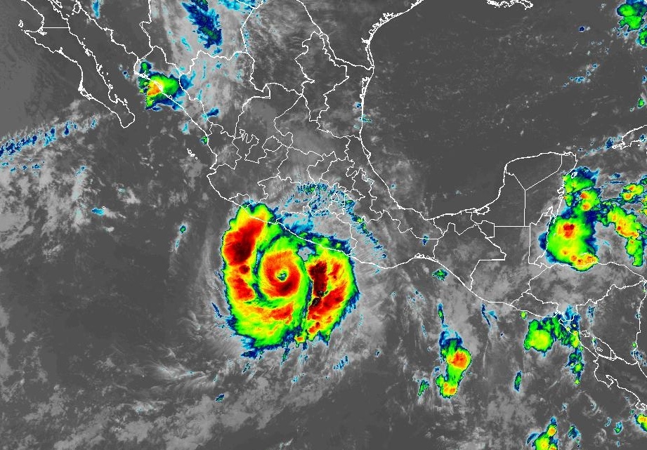
Hurricane Polo rapidly intensified into a Category 5 storm with 180 mph winds near Mexico’s Pacific coast, prompting evacuations and warnings of flooding, mudslides, and hazardous conditions despite no expected direct landfall.
Image Credit: PBS
The event described in this article is currently ungoing. Please check sources.
*This article was last updated September 23, 2026.
Hurricane Polo rapidly intensified into one of the most powerful Pacific cyclones in decades on Tuesday, reaching Category 5 status with maximum sustained winds of 180 mph (290 kph), according to the Miami-based National Hurricane Center. The storm, described as extremely dangerous, was centered 210 miles (338 kilometers) south of Zihuatanejo, Mexico, and remained nearly stationary over the Pacific Ocean at midday. Forecasters expect Polo to skirt Mexico’s southwestern coast in the coming days, moving in a generally west-northwestward direction.
The hurricane’s rapid intensification, fueled by El Niño, has drawn comparisons to Hurricane Patricia, which reached 215 mph (346 kph) in 2015, making Polo one of the strongest storms ever recorded in the Pacific Basin. This season has already seen two other Category 5 hurricanes, Genevieve and Lowe, and Polo marks the third. The National Hurricane Center warned that even if Polo does not make direct landfall, it could still produce life-threatening flooding, mudslides, and hazardous ocean conditions, including deadly rip currents and rogue waves.
Mexican authorities have taken precautions, temporarily suspending classes in Pacific coast states such as Guerrero and Michoacán, where heavy rain and strong winds are expected. In Acapulco, a city still recovering from the devastation of Hurricane Otis in 2023, fishing boats were pulled onshore as dark clouds swirled above choppy seas. The U.S. Embassy in Mexico issued a weather alert, urging citizens to avoid beaches and heed warnings from local authorities. Mexican President Claudia Sheinbaum reassured the public that experts do not expect Polo to touch land, but the Navy shut down ports in Guerrero and Michoacán as a precaution.
Residents along the coast expressed concern as the storm approached, with many recalling the destruction caused by Otis, which left little time for preparation due to its rapid intensification. Authorities in Acapulco used megaphones to broadcast safety messages, urging people to take preventive measures and locate their nearest shelters. The storm is expected to bring 3 to 6 inches (8 to 15 centimeters) of rain to Guerrero and Michoacán, with smaller amounts possible in coastal areas of Oaxaca, Colima, and Jalisco. Strong winds and rough surf are also anticipated. Meanwhile, Tropical Storm Odalys, far from land, is forecast to become a hurricane later this week.